Early detection and fast response can stop a small flame from becoming a disaster. This article looks at wildfire fighting drones and the XPRIZE competition pushing teams to build systems that both find heat and act on it. It explains how thermal sensors, onboard intelligence and suppression payloads work together, why regulation and coordination with fire services matter, and what realistic capabilities we can expect in the coming years.
Introduction
If you live in or near forested areas, you may wonder whether technology can spot a smoulder early enough to prevent evacuation or worse. That practical concern is exactly what engineers and agencies test in trials connected to the XPRIZE Wildfire Challenge: can an airborne system reliably find tiny hot spots, notify authorities quickly, and in some cases apply suppression without putting firefighters at risk?
The XPRIZE competition frames this technical task as a contest: teams design autonomous systems that combine sensing, decision-making and safe delivery of water or retardants. Trials mix lab data and outdoor runs under realistic smoke and terrain. Readers will get a clear view of the main technical building blocks, concrete examples from field tests, the regulatory and safety tensions involved, and what plausible deployments might look like in the next few years.
How wildfire fighting drones detect and act
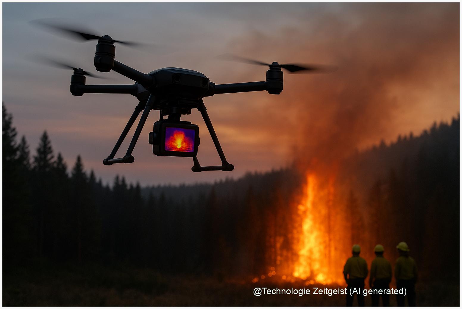
At the core are three linked systems: sensors that detect heat or flame, software that classifies and locates the threat, and a platform capable of delivering information or suppression payloads. Thermal cameras—often long-wave infrared (LWIR)—see heat through smoke and darkness better than ordinary cameras. They produce a heat map; an algorithm then separates likely fire from other warm objects such as sunlit rocks or exhaust.
Speed in detection and accuracy in classification decide whether a drone helps contain a fire or merely adds data to a busy incident room.
Sensors come in tiers: small LWIR units for short-range scanning, higher-resolution thermal or mid-wave infrared (MWIR) for longer ranges, and multispectral setups that combine visible and thermal views for better false-positive control. Navigation uses GNSS plus inertial sensors; many prototypes add lidar or radar for obstacle awareness in smoke and wind.
When suppression is required, there are two common approaches. One uses autonomous or remotely piloted multi-rotor platforms carrying liters of water or gel for targeted drops over hotspots; the other uses fixed-wing systems or tethered platforms to deliver larger volumes but with less pinpoint accuracy. Fully autonomous suppression—where the drone decides to release a payload without human sign-off—is rare in trials; most systems use a human-in-the-loop for safety and legal reasons.
Thermal detection ranges reported in trials and technical literature vary widely depending on sensor quality and altitude; typical practical values range from around 100 m for small sensors to several hundred metres for higher-end systems. These figures are approximate and depend heavily on smoke density, terrain and weather.
| Feature | Description | Typical value |
|---|---|---|
| Small LWIR | Lightweight thermal camera for close-range scans | ~100–200 m |
| High-end MWIR/LWIR | Higher resolution, better through-smoke performance | ~300–1,000 m |
| Multispectral + AI | Combines thermal and visible imagery with classifiers to reduce false alarms | Improved precision (variable) |
Field tests and practical uses
Trials linked to the XPRIZE and other research programmes typically separate two tasks: surveillance and suppression. Surveillance flights map heat signatures and produce actionable alerts for incident command. Suppression tests measure whether a mechanical release of water or gel can reliably quench a small fire under realistic wind and slope conditions.
In practice, teams run repeated scenarios: starting fires of controlled size, flying preprogrammed search patterns, and coordinating with a ground control station that simulates a fire service. Trials show that a combined approach works best: drones sweep wide areas to find hot spots, then a smaller precision platform inspects and, if authorised, applies a treatment. For reasons of safety and liability, many demonstrations keep a human operator as final decision-maker for payload release.
Another practical task is persistence: how long can a system patrol an at-risk landscape? Multi-rotor platforms tend to have shorter endurance—tens of minutes to a few hours with battery swaps—while hybrid or fixed-wing drones reach longer coverage but need prepared landing areas. Real-world deployments therefore mix types depending on mission: quick response and precision close-in, longer patrols for early warning.
Data integration matters as much as hardware. Trials that succeed combine drone feeds with meteorological data and local fire maps, so an alert goes directly into an incident management console rather than as an isolated message. Interoperability with existing systems is a common requirement in XPRIZE-style judging criteria, and it is also a practical necessity for operational adoption.
Benefits, limits and tensions
Wildfire fighting drones offer clear benefits: faster detection in remote terrain, reduced exposure of crews to dangerous conditions, and higher-frequency monitoring of vulnerable areas. For municipalities and forestry services, that can mean fewer surprises during dry seasons and better allocation of ground crews and aircraft.
However, limitations and tensions are real. False positives—warm objects mistaken for fire—create distracting alerts unless classification is robust. Environmental factors such as heavy smoke, rain or dense canopy reduce sensor effectiveness. Logistics and cost also matter: resilient platforms with redundancy and longer endurance are expensive, and communities must weigh capital and operational costs against expected reductions in fire damage.
Regulation is another friction point. Authorities set strict rules for BVLOS (beyond visual line of sight) flights and payload delivery. Most trials operate under special permissions; broad commercial use requires certified procedures, reliable command-and-control links, and clear liability rules in case of an accident or a mistaken release of suppressant.
Ethical and ecological questions also arise. Chemical retardants can harm waterways if applied incorrectly; repeated drone flights may disturb wildlife. Transparency about when and how suppression is used, and careful environmental assessment in trials, are therefore necessary parts of any deployment plan.
Where the technology and rules are heading
Regulators and research institutions have pushed forward in recent years, creating frameworks that make structured trials possible. European and U.S. aviation authorities published guidance and test corridors that helped projects move from prototypes to larger demonstrations in 2023–2024; those documents are now more than two years old and therefore in need of current review for local applicability.
Technically, the next steps are incremental: better sensor fusion to lower false positives, improved endurance through hybrid propulsion or swappable batteries, and standardized APIs so drone data plugs directly into incident command software. On the suppression side, companies explore pre-measured gel payloads and precise micro-drops that minimize environmental harm while increasing effectiveness.
For communities, the likely scenario is a mixed fleet: persistent fixed-wing drones for broad surveillance, agile multirotors for inspection and small suppression tasks, and manned aircraft for large-scale water or retardant delivery. Wider deployment depends on harmonized regulation, cost reductions, and proven proof-of-concept results from competitions and pilot programmes such as XPRIZE.
Finally, public acceptance matters. Clear rules about data use, transparent reporting of trial results, and visible coordination with local fire services will determine whether the technology is perceived as a helpful tool or as intrusive hardware.
Conclusion
Wildfire fighting drones are maturing from experiments into practical tools for detection and small-scale suppression, but they are not a single quick fix. Effective systems combine thermal and multispectral sensing, robust classification algorithms, reliable navigation and carefully managed suppression mechanisms. Competitions like the XPRIZE help accelerate engineering effort and produce comparable demonstrations, but wider adoption will follow only after regulators, emergency services and communities agree on safe procedures and shared standards.
In the near term, expect more mixed fleets in trials, clearer BVLOS corridors from aviation authorities, and incremental technical improvements that reduce false alarms and increase endurance. The practical benefit for residents and firefighters will be timelier alerts and fewer risky ground missions—provided the systems are integrated sensibly and operated under strict safety rules.
Share your perspective or local experiences with drone trials—constructive conversation helps shape safer deployments.


Leave a Reply